The "Missing" chart of Java and Sumatra - 1598

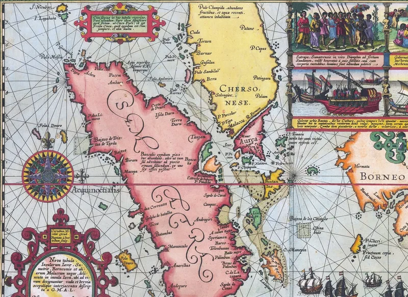
This remarkable maritime chart documents the first Dutch fleet’s voyage - captained by Cornelis de Houtman - through southern Malaya, Sumatra, Java, southern Borneo and islands east of Java to Sumbawa.
The map shows Pulo Pinaon [Pulau Pinang] as well as Cuda [Kedah].
It’s considered the first accurate detailed record of Java’s north coast created by Europeans and features seven scenes depicting the fleet’s adventures, in stunning colour. This expedition and the resulting nautical knowledge gained by the Dutch would contribute to the demise of the Portuguese monopoly of the spice trade in the East Indies in the subsequent decades.
In 1598, Amsterdam publisher Cornelis Claesz released an acclaimed account of this voyage that sold many editions in Dutch and Latin. The book curiously mentioned, at the end of Chapter 19, “Here follows the chart of Java”. However, no copy of any edition included it. The “missing” map was published separately later that same year.
Its creator was Willem Lodewijcksz (an officer on the voyage) who only included a cryptic initial “G.M.A.L.” to hide his identity; it was only deciphered centuries later as “[G]uilielmus [M]. [A]lias [L]odewycksz.”
In one of the cartouches (explanatory box) of the map is the following note in Latin: “Cum sępius in hac tabula reperias Puro notandum, Puro idem significare quod fretum, ut Cinca Puro, id est fretum Cinca, quod oppidum est Tanjampuro, et alia multa.” — As you often find on this map, I think it should be noted that puro means the same as strait, as in Cinca Puro [Singapura], that is, the Strait of Cinca, which is the town of Tanjampuro, and many others.
Lodewycksz seems to have thought, incorrectly, that “Puro” meant “Straits.”
However, he correctly states in another note: “Cum sępius hîc occurrat P, sive Pulo, sciendum, Pulo lingua Malayca insulam significare”—Since ‘P’ or ‘Pulo’ appears frequently here, it should be known that Pulo means ‘island’ in the Malay language.
Source:
- Thomas Suarez (2012), “Early Mapping of Southeast Asia”, pg. 180
- Latin translations mine.