The Earliest Known Map of George Town (1786)

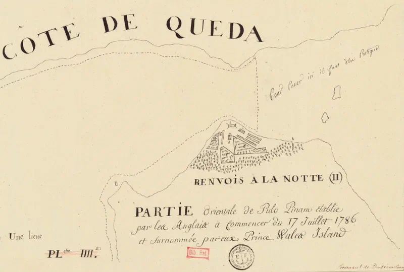
A French reconnaissance mission may have given us the oldest surviving plan of Penang’s capital.
In October 1786, Captain Antoine Bruni d’Entrecasteaux set sail from Pondicherry, India, on the frigate Résolution, accompanied by the corvette Subtile. The Résolution was formerly HMS Romulus, a 44-gun ship of the British Royal Navy captured by the French at Chesapeake Bay during the American Revolutionary War.
Officially, the mission was to survey Southeast Asian ports, but it had a secret purpose. As French historian Henri Cordier revealed in 1903: “The real purpose of d’Entrecasteaux’s mission… was to inform [the French in] China of the future designs of the English against that great empire.”
His orders were to reconnoitre strategic locations including Mergui, Malacca, and Manila, assessing whether Spain might provide “Succour” against England in the event of war.
The expedition, making slow progress as they had to sail against the monsoon winds due to a late departure, would have reached Pulau Pinang – marked as “Pulo Pinam” on this map – in late 1786, just months after Captain Francis Light established his settlement at Tanjung Penaga. From the route taken by the Résolution, this chart would have been made during this outward leg of the journey in 1786 to Canton as it shows a northern approach to Penang.
This map, recently made available by the Bibliothèque nationale de France, is now the earliest known plan of George Town† – predating the often-reproduced 1792 Popham plan by several years.
Unfortunately, the accompanying “Renvois à la note” (key/legend) has not been found. Place identifications are based on Capt. Light’s journal, his 1787 letter to Andrew Ross, and Fr. Garnault’s correspondence with Fr. Letondal.
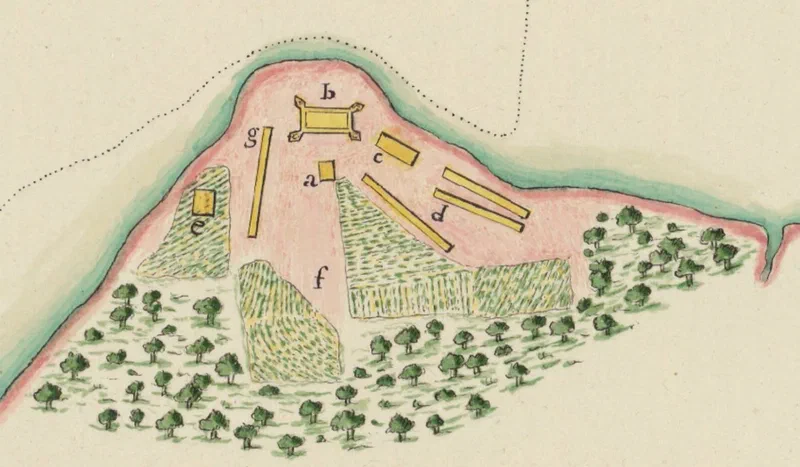
Places marked on the map:
(a) The Church of the Assumption – then just an unnamed wooden building. According to a letter by Fr. Garnault dated 4th June 1787, he set “sail on the 22nd [February 1787] upon an English Vessel which, at the Request of the Governor [Capt. Light] of my new Residence, Pulo-Pinang, carried me to Pondicherry”. He returned on Assumption Day later that year (15th August).
(b) Fort Cornwallis – merely a stockade of nibong palm wood
(c) Buildings along future Beach Street (wooden structures, per Light’s records)
(d) Building along future King Street
(e) Capt. Light’s house – present-day Convent Light Street
(f) Paddy fields along future Penang Road (also shown in Popham’s later map)
(g) The sepoy lines (barracks)
(h) Sungai Pinang
Sources:
- Henri Cordier (1911), “La mission de M. le chevalier d’Entrecasteaux à Canton en 1787”
- Susan E. Schopp (2020), Sino-French Trade in Canton (1698–1842), p. 122
- BNF: “Partie orientale de Pulo Pinam etablie par les Anglais…” (ark:/12148/btv1b53297429b)
† A note on the name: Contrary to popular belief, East India Company records show that “George Town” was only officially adopted in 1794.