Pulo Pinaon (1561)

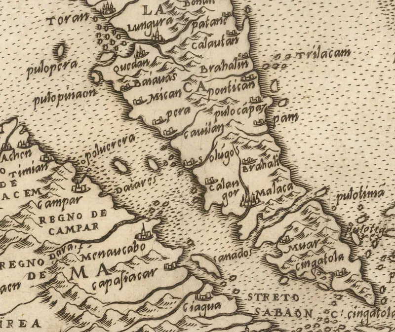
Four and a half centuries ago, a Venetian mapmaker sat down to draw the edge of the known world, and somewhere in that tangle of coastline he labelled a small island off the coast of Kedah: Pulo Pinaon. It is the Portuguese rendering of Pulau Pinang – and it means the island was already on the map, already known to the sailors and traders whose reports found their way to Europe.
The map is Il Disegno Della Terza Parte Dell’Asia – ‘The Map of the Third Part of Asia’ – published in 1561. The man behind this magnificent masterpiece was Giacomo Gastaldi (1500–1566), widely regarded as the foremost Italian cartographer of the sixteenth century. Born in Piedmont, he settled in Venice by 1539 and came to mapmaking only in his forties, after a career as an engineer. There he made his name as an engraver and cosmographer, rising to become cosmographer to the Republic of Venice.
Run your eye down the Straits of Malacca and the names start to feel familiar, if you squint a little: Quedah (Kedah), Pera (Perak), Pulo Pinaon (Pulau Pinang), Calangor (Selangor), Malaca (Melaka), Muar, and Singatola (Singapura).
One of the map’s more intriguing features is a table setting each place name of the day beside its counterpart from antiquity. There, the promontory at the tip of Asia – Ptolemy’s mysterious Malæi Colon – is matched to Capo Cingapola, the Cape of Singapura.
Sources:
- Thomas Suarez (2012), ‘Early Mapping of Southeast Asia’
- T. Osborne (1748), ‘An Universal History, from the Earliest Account of Time’, Volume XX