Portuguese Description of Batu Ferringhi (1699)

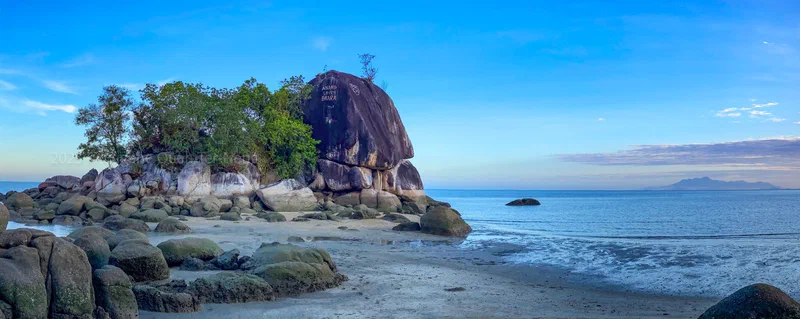
Photo of Batu Ferringhi during the lowest spring tide earlier in the year, with Gunung Jerai in the distance across the bay of Pasir Elok.
Ever wondered where “Batu Ferringhi” got its name?
The word farangī (فرنگی) originally referred to the medieval Franks – a term for Western European Christians – and in Persian came to mean Westerners in general. Through Persian and North Indian usage (compare Hindi‑Urdu firangī), it entered Malay as feringgi (and Thai as farang).
When Captain Thomas Forrest surveyed Penang’s coast in 1784, he noted that Feringgi referred to the Portuguese. The Malay place name Batu Ferringhi literally means ‘Foreigner Rock’. This rocky islet served as a landmark for sailors watering at the nearby sandy bay – a stretch fittingly known in Malay today as Pasir Elok, meaning ‘beautiful sand’.
How do we know the Portuguese once watered here? In 1699, Manoel Pimentel, the Portuguese royal cosmographer, provided a description of a watering place that closely corresponds to the coastline and landforms of this part of Penang’s north shore in his nautical treatise, the ‘Arte de navegar’:
‘From Pulo Pera [Pulau Perak] to Pulo Pinaõ [Pulau Pinang] is 18 leagues. Pulo Pinaõ lyeth in the height of 5 degrees 26 minutes, and is about 5 leagues in length. It runneth along the coast; in the middle the land riseth high, & on its Northern point it formeth a rounded hill, & midway along it there standeth a small isle. Sailing along the shore, you come upon a great bay with a sandy beach, & at the end thereof lyeth the little island where there is a watering place …’
Original Portuguese:
‘De Pulo Pera a Pulo Pinaõ ha 18 léguas. Pulo Pinaõ está em altura de 5 gr. 26 min. terá de comprido 5 leguas. Está ao longo da costa: no meyo he alta, & na ponta da parte do Norte faz hum morro redondo, & no meyo della está hum ilheo. E vindo ao longo da terra faz hũa enseada grande com hũa praya de area, & no cabo della está o ilheo onde tem hũa aguada …’
That ’little island’ with the watering place? That’s Batu Ferringhi itself – a rocky islet recorded in Malay as Tukun Batu Ferringhi and popularly known as Lover’s Isle.
Source:
Manoel Pimentel (1699), “Arte de navegar, em que se ensinão as regras praticas, e Roteiro das viagens, e costas maritimas de Guiné, Angola, Brazil, Indias, e Ilhas Occidentaes, e Orientaes” (Lisbon, 1699), pg. 361.
Thomas Forrest (1792), “A Voyage from Calcutta to the Mergui Archipelago, Lying on the East Side of the Bay of Bengal; …”