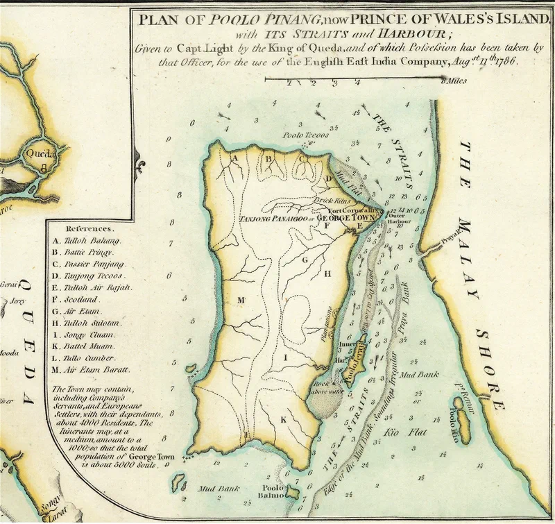
Popham's map of Poolo Pinang (1798)

Rare coloured version of the map of “Poolo Pinang, now Prince of Wales Island”, published in 1798 by Laurie & Whittle. It is based on Captain (later Sir) Home Riggs Popham’s surveys, a contemporary of Captain Light who visited Penang in 1792.
It is interesting to note that all the names of the places are in Malay except for Scotland and George Town (Tanjung Penaga). Some of the names have survived till this day, after more than 230 years.
A. Tulloh Bahang - Teluk Bahang
B. Battie Pringy - Batu Ferringhi
C. Pasir Panjang - Now Teluk Tikus or Tanjung Bungah Beach
D. Tanjong Tecoos - Tanjong Tokong (Stamford Raffles referred to it as Pulau Tikus Point in 1807)
E. Tulloh Air Rajah - Teluk Ayer Rajah
F. Scotland - Highlands of Scotland (the hills behind the Turf Club) along Scotland Road
G. Air Etam - Air Itam
H. Tulloh Sulotan (Selatan) - Jelutong area
I. Songy Cluam - Sungai Keluang
K. Battel Muam - Batu Maung
L. Tulloh Cumber - Teluk Kumbar
M. Air Etam Baratt (West) - Balik Pulau / Barat Daya District