Linschoten's map and the earliest written account of Penang (1596)

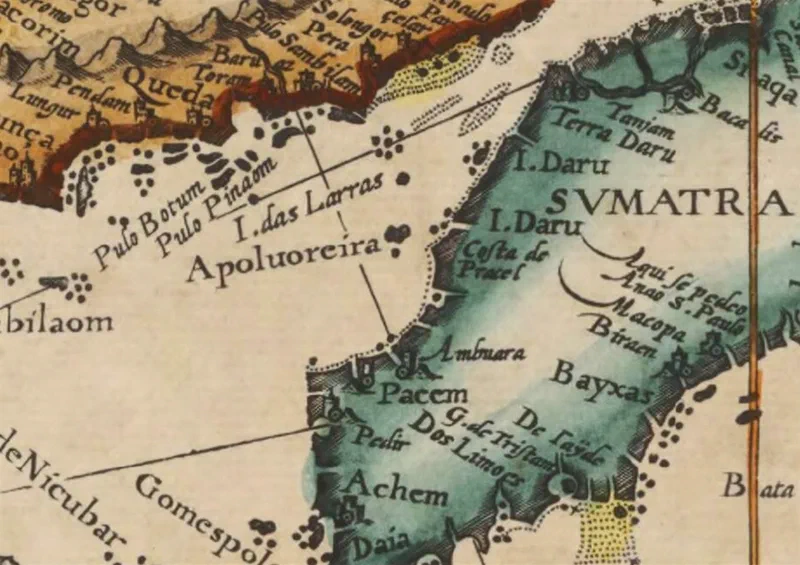
Map of the Straits of Malacca published in 1596 showing Penang (Pulau Pinaom) and Kedah (Queda).
The Dutch merchant, adventurer and writer Jan Huyghen van Linschoten copied, while in Goa in the 1580s, the nautical charts which were a closely kept secret by the Portuguese for over a century. He also amassed a vast amount of descriptions of the countries, trading routes and navigational information collected from the cosmopolitan residents of Goa he met. This act of trade espionage would ultimately reshape the world.
In 1596, he published the information in his book, “Itinerario: Voyage ofte schipvaert van Jan Huygen van Linschoten naer Oost ofte Portugaels Indien, 1579-1592” (Travel account of the voyage of the sailor Jan Huygen van Linschoten to the Portuguese East India). This precious knowledge enabled the Dutch and later the British to break Portugal’s monopoly of East Indian trade. And this indirectly led to the creation of the British East India Company which then facilitated the rise of the British Empire.
His book contains what is likely the earliest written account of Pulau Pinang, spelt as Pulo Pinaon or Pinaom:
“This Island Pulo Pinaon lyeth 5. miles from the firme land, full under five degrees and 1/4 the marke thereof is, that it is high in the middle, having on the North point a round houvell [hill] and an Island lying in the middle way from the same Island, and coming along by the land, it hath a great creek with a sandy strand …”
Although published in 1596, it predates the account of Sir James Lancaster, who was the first named European to have visited Penang in 1592. This is because Linschoten collected his description of Penang between 1579 and 1592. Lancaster also called the island by the Portuguese pronunciation of its Malay name.
Sources:
- Jan Huygen van Linschoten (1596), “Itinerario: Voyage ofte schipvaert van Jan Huygen van Linschoten naer Oost ofte Portugaels Indien, 1579-1592”
- Petrus Plancius (1596) - Map - “Exacta & accurata delinatio cúm orarum maritimarum túm etjam locorum terrestrium quæ in regionibus China, Cauchinchina, Camboja, sive Champa, Syao, Malacca, Arracan & Pegu”
- Clements R. Markham (1877), “The voyages of Sir James Lancaster, Kt., to the East Indies”