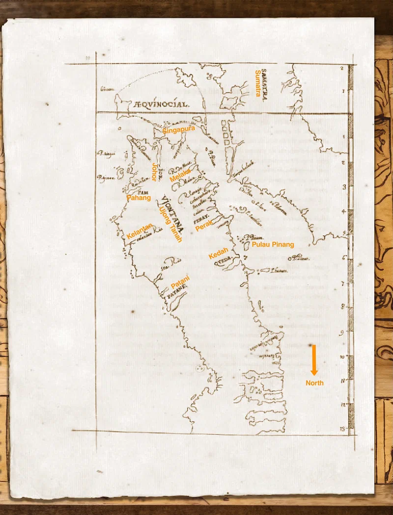
Erédia's map of the Straits of Malacca

Manuel Godinho de Erédia’s map of the Straits of Malacca. He was a Bugis-Portuguese writer and cartographer who was born in Malacca. Queda (Kedah) and Pulo Pinam (Pulau Pinang) can be seen in this chart. It was probably based on his surveys before 1604, as he left for Goa the following year.
Translation and annotations mine:
In naval warfare, they [the Malays] employ different, smaller vessels, such as “lancharas” [lanchang] and “bantis” [brigantine], which are rowed by breast oars, and are likewise equipped with two rudders and masts. For fishing and river trade, they use “ballões” [boats - perahus/prau] and “nambangues” [prau tambang - ferry?], propelled by small hand-held oars, moving swiftly in harmony with the chanting of their rowers. From this, it may be inferred that the Malays do not engage in oceanic navigation, for they only sail by coasting along the shores of Viontana [Ujong Tanah, Land’s End - Johor], from the district of Pattane [Pattani], by the cape of the islet Pulo Catay (Pulo Cara/Ko Kra เกาะกระ) at the latitude of 8 degrees on the eastern coast, to the western coast of Viontana, at the same latitude in the district of Queda [Kedah], in Taranda [Trang] and Vion Calan [Ujong Salang - Phuket], which are regions where the Malay language is spoken.
It is noteworthy that the eastern coast of Viontana was settled and frequented before the western coast, as is evidenced by the histories, which reveal that Pattane and Pam [Pahang] were Malay territories before the founding of Malacca. The King of Pam [Pahang] governed Syncapura [Singapura], though the monarch resided in Pattane, the metropolis of the Malays, which was tributary to the empire of Siam, as the Malays to this day acknowledge its supremacy. However, the principal empire and governance were under the Emperor of Attay [Ayutthaya - Siam], as the Indies, both within and beyond, and the southern regions were tributaries, and their ports were open to oceanic navigation with vessels of a different design from those of Europe.
Notes: \
- During Erédia’s time, the capital “V” in Portuguese when in front of a word sounded like “u”. \
- The Dutch, French and English used the Portuguese spelling of Pulau Pinang (variously spelled as Pulo Pinão (Bocarro), Pulo Pinaon (Lancaster), Pulo Pinam (Erédia), Pulo Pinaom (Linschoten), etc.) \
- bantis is a contraction for bargantis or bergantim (brigantine). Although in the Indian sense it refers to “smaller boats for rowing”.
Source:
- Erédia (1613). “Declaracam de Malaca e India Meridional com o Cathay”. 1881 facsimile reproduction of the original Portuguese manuscript: https://eservice.nlb.gov.sg/flipviewer/data/booksg_publish/b/b44dd395-4a9a-4394-a9bf-4b7745a8eb74/web/html5/index.html?/BOOKSG.xml&launchlogo=tablet/BOOKSG_BrandingLogo_.png&pn= , Cap. 13 De Embarcacoes, Folio 25-26.
- Sternstein (1993), “The Journal of the Siam Society Vol. 81, Pt. II (1993)”, pg. 50-57
- Casale (2014), “Ottoman Warships in the Indian Ocean Armada of 1538: A Qualitative and Statistical Analysis,” in Dejanirah Couto, Feza Günergün and Maria Pia Pedani, eds., “Seapower, Technology and Trade: Studies in Turkish Maritime History”
- Hashmatrai Lekhraj Chablani (1929), “The Economic Condition of India During the Sixteenth Century”, pg. 64
