An Excellent Map: The Portuguese and the Lost Heritage of Javanese Map-making (c. 1513)

On April 1, 1512, Afonso de Albuquerque, Governador da Índia (Governor of India), who had recently conquered Malacca in August 1511, wrote to Manuel I, the King of Portugal:
“Your Majesty, I have the further pleasure of presenting a fragment from a large map made by a Javanese navigator… I have never seen such an excellent map. I have no doubt that this will please Your Majesty… Names on the map were transcribed from the original written in Javanese letters with the help of the Javanese. This was copied from the original Javanese map by Francisco Rodriguez… The original map was lost when the Flor de la Mar was wrecked. This copy was made by the painstaking efforts of two pilots, Francisco Rodriguez and Pedro d’Alpoym [d’Alpoim]. This is a very precious and detailed map showing even the sea routes to places where the Javanese go …”
Albuquerque had acquired ũa gramde carta (a large map) from a Javanese pilot shortly after the subjugation of Malacca. Rodrigues’ copy of the Javanese chart was long presumed lost, suffering the common fate of old charts “through sheer neglect” as Portuguese surveying and cartography progressed; “some may have been deliberately destroyed following the secrecy enjoined … by Royal Decree … with respect to all maps … connected with navigation south of the equator”.
In 1849, the 2nd Viscount of Santarém published an atlas which came to be known as “Atlas do Visconde de Santarém”. It intriguingly included “copies of the twenty-six charts which he believed were drawn originally between 1524 and 1530.” Unfortunately, Santarém had dated them incorrectly and failed to recognise their connection to Rodrigues.
Writing a century later, in 1949, Heinrich Winter, a pioneer in modern cartography, noted that it was the Portuguese cartographer “Armando Cortesão who succeeded, after much labour, in tracing the original manuscript”. It was found in France’s Bibliothèque de l’Assemblée Nationale in Paris, filed under the title “Journal de Francisco Roïs, pilote de la flotte portugaise” (Journal of Francisco Roïs, Pilot of the Portuguese Fleet). The library notes that Roïs was “also known as Rodrigues.”
Rodrigues served as one of the pilots in the fleet dispatched by Afonso de Albuquerque in November 1511 to explore the Moluccas, under the command of Antonio de Abreu. Departing from Malacca, Rodrigues’ vessel charted the southern reaches of the Moluccan archipelago: Ambon, Seram, and the Banda Islands.
Cortesão went on to identify “all the place-names. Most important of all, he concluded that the whole work must have been finished by 1513 at the latest.” Rodrigues’ Journal, which included the set of charts, was found together with his own copy of the better-known Suma Oriental by Tomé Pires.
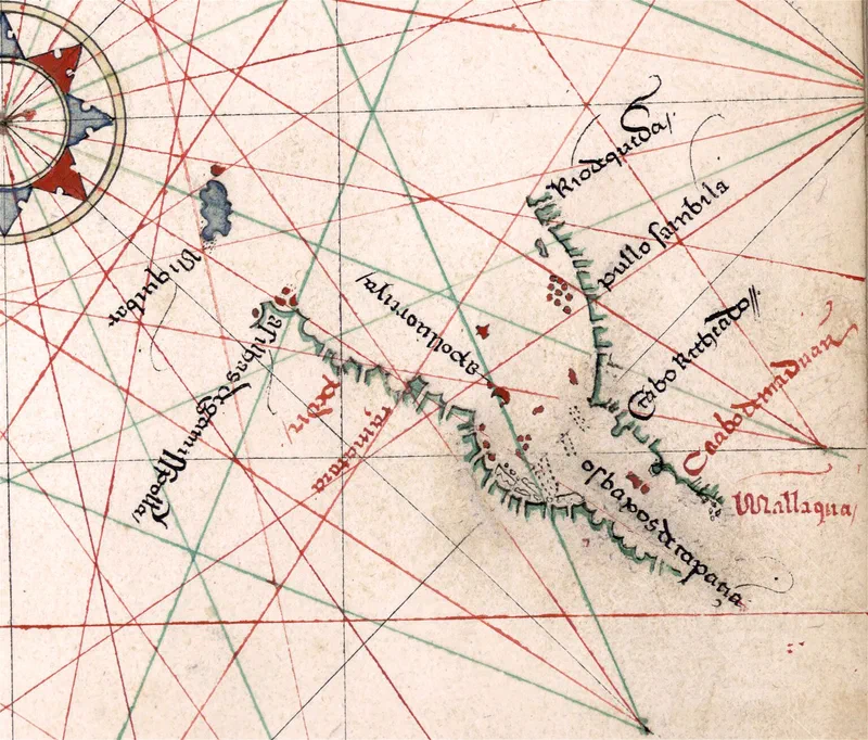
In 1995, J.H.F. Sollewijn Gelpke attempted to reconstruct Albuquerque’s now-lost Javanese map by comparing the surviving fragments found in Rodrigues’ Journal; he noted that some of Rodrigues’ surviving charts also incorporated elements of Arab and Chinese map-making traditions. Hiroshi Nakamura, an editor of the noted map-making journal Imago Mundi, wrote in his study Tōa no Kochizu (History of Mapping of Eastern Asia) that within the set was “the first map that shows the East Indies [with some accuracy] … considering the age when this map was drawn, and the fact that this is not the original but a copy, this is amazingly well done.”
One of the charts was the first map referencing Malacca after it fell into Portuguese hands; it appears as Mallaqua. Other places of interest include Pullo Sainbila (Pulau Sembilan). Pulau Pangkor, then known as Pulo Dinding on charts, was then considered part of the group of nine islands. Thus, the unnamed island with a red dot just south of Rio do Queda (River of Kedah) is likely Pulau Pinang (Penang) - which was named in earlier Chinese charts and Arabic navigation guides.
Rodrigues’ charts reveal that detailed geographic knowledge was already widespread across Asia before the Portuguese arrived. By absorbing this local expertise into their own maps, the Portuguese gained a decisive edge in navigating the region - allowing them to dominate the spice trade and shut out rival European powers until the Dutch eventually acquired those navigational secrets themselves.
Sources:
- Heinrich Winter (1949), “Francisco Rodrigues’ Atlas of ca. 1513,” Imago Mundi, Vol. 6, pp. 20–26
- J.H.F. Sollewijn Gelpke (1995), “Afonso de Albuquerque’s Pre-Portuguese ‘Javanese’ Map, Partially Reconstructed from Francisco Rodrigues’ Book,” Bijdragen tot de Taal-, Land- en Volkenkunde, Deel 151, 1ste Afl., pp. 76–99
- Francisco Rodrigues (c. 1513), “Journal de Francisco Roïs, pilote de la flotte portugaise,” Ms. 1248 (Manuscript in Portuguese), Bibliothèque de l’Assemblée nationale, Paris.
- Hiroshi Nakamura (1962), “East Asia in Old Maps,” pp. 29–32
- Giovanni Pedrini (2020), “Imago Orientis – Venezia e gli Orienti geografie dell’Asia”