August 2025

Browse the archive
202655
202558
202455
202338
202224

An Excellent Map: The Portuguese and the Lost Heritage of Javanese Map-making (c. 1513)

On April 1, 1512, Afonso de Albuquerque, Governador da Índia (Governor of India), who had recently conquered Malacca in August 1511, wrote to Manuel I, the King of Portugal:

“Your Majesty, I have the further pleasure of presenting a fragment from a large map made by a Javanese navigator… I have never seen such an excellent map. I have no doubt that this will please Your Majesty… Names on the map were transcribed from the original written in Javanese letters with the help of the Javanese. This was copied from the original Javanese map by Francisco Rodriguez… The original map was lost when the Flor de la Mar was wrecked. This copy was made by the painstaking efforts of two pilots, Francisco Rodriguez and Pedro d’Alpoym [d’Alpoim]. This is a very precious and detailed map showing even the sea routes to places where the Javanese go …”

Albuquerque had acquired ũa gramde carta (a large map) from a Javanese pilot shortly after the subjugation of Malacca. Rodrigues’ copy of the Javanese chart was long presumed lost, suffering the common fate of old charts “through sheer neglect” as Portuguese surveying and cartography progressed; “some may have been deliberately destroyed following the secrecy enjoined … by Royal Decree … with respect to all maps … connected with navigation south of the equator”.

In 1849, the 2nd Viscount of Santarém published an atlas which came to be known as “Atlas do Visconde de Santarém”. It intriguingly included “copies of the twenty-six charts which he believed were drawn originally between 1524 and 1530.” Unfortunately, Santarém had dated them incorrectly and failed to recognise their connection to Rodrigues.

Writing a century later, in 1949, Heinrich Winter, a pioneer in modern cartography, noted that it was the Portuguese cartographer “Armando Cortesão who succeeded, after much labour, in tracing the original manuscript”. It was found in France’s Bibliothèque de l’Assemblée Nationale in Paris, filed under the title “Journal de Francisco Roïs, pilote de la flotte portugaise” (Journal of Francisco Roïs, Pilot of the Portuguese Fleet). The library notes that Roïs was “also known as Rodrigues.”

Rodrigues served as one of the pilots in the fleet dispatched by Afonso de Albuquerque in November 1511 to explore the Moluccas, under the command of Antonio de Abreu. Departing from Malacca, Rodrigues’ vessel charted the southern reaches of the Moluccan archipelago: Ambon, Seram, and the Banda Islands.

Cortesão went on to identify “all the place-names. Most important of all, he concluded that the whole work must have been finished by 1513 at the latest.” Rodrigues’ Journal, which included the set of charts, was found together with his own copy of the better-known Suma Oriental by Tomé Pires.

In 1995, J.H.F. Sollewijn Gelpke attempted to reconstruct Albuquerque’s now-lost Javanese map by comparing the surviving fragments found in Rodrigues’ Journal; he noted that some of Rodrigues’ surviving charts also incorporated elements of Arab and Chinese map-making traditions. Hiroshi Nakamura, an editor of the noted map-making journal Imago Mundi, wrote in his study Tōa no Kochizu (History of Mapping of Eastern Asia) that within the set was “the first map that shows the East Indies [with some accuracy] … considering the age when this map was drawn, and the fact that this is not the original but a copy, this is amazingly well done.”

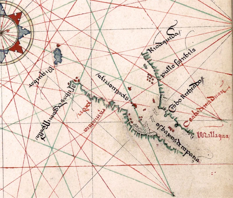
One of the charts was the first map referencing Malacca after it fell into Portuguese hands; it appears as Mallaqua. Other places of interest include Pullo Sainbila (Pulau Sembilan). Pulau Pangkor, then known as Pulo Dinding on charts, was then considered part of the group of nine islands. Thus, the unnamed island with a red dot just south of Rio do Queda (River of Kedah) is likely Pulau Pinang (Penang) - which was named in earlier Chinese charts and Arabic navigation guides.

Rodrigues’ charts reveal that detailed geographic knowledge was already widespread across Asia before the Portuguese arrived. By absorbing this local expertise into their own maps, the Portuguese gained a decisive edge in navigating the region - allowing them to dominate the spice trade and shut out rival European powers until the Dutch eventually acquired those navigational secrets themselves.
An Excellent Map: The Portuguese and the Lost Heritage of Javanese Map-making (c. 1513) — image 1

Sources:

  1. Heinrich Winter (1949), “Francisco Rodrigues’ Atlas of ca. 1513,” Imago Mundi, Vol. 6, pp. 20–26
  2. J.H.F. Sollewijn Gelpke (1995), “Afonso de Albuquerque’s Pre-Portuguese ‘Javanese’ Map, Partially Reconstructed from Francisco Rodrigues’ Book,” Bijdragen tot de Taal-, Land- en Volkenkunde, Deel 151, 1ste Afl., pp. 76–99
  3. Francisco Rodrigues (c. 1513), “Journal de Francisco Roïs, pilote de la flotte portugaise,” Ms. 1248 (Manuscript in Portuguese), Bibliothèque de l’Assemblée nationale, Paris.
  4. Hiroshi Nakamura (1962), “East Asia in Old Maps,” pp. 29–32
  5. Giovanni Pedrini (2020), “Imago Orientis – Venezia e gli Orienti geografie dell’Asia”

https://www.eugenequah.com/blog/an-excellent-map-the-portuguese-and-the-lost-heritage-of-javanese-map-making-c.-1513/

Copyright © 2026 Eugene Quah Ter-Neng. All rights reserved.

The Roar of Krakatoa Across the Straits of Malacca (1883)

Sunday, 26 – Monday, 27 August

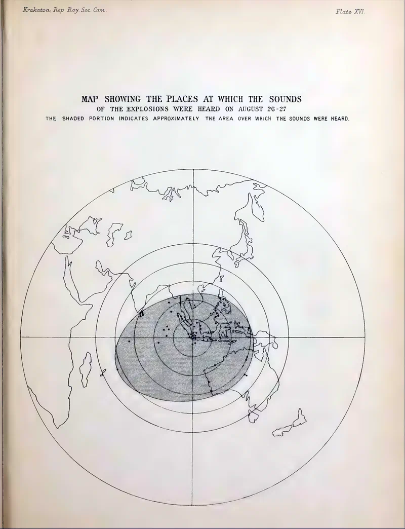
On a Monday morning in August 1883 – exactly 142 years ago to the day – residents of Penang in the Straits Settlements, at the northern entrance of the Straits of Malacca, thought they heard “a salute from an American corvette” in port. Such sounds were common and usually passed without a second thought. This time, however, they were mistaken: the ship had left four hours earlier.

A correspondent at Selangor, whose account was later published in the Straits Times, said he heard the same sounds, described as “like the firing of a man of war at general quarters 3 or 4 miles off. The peculiarity of the concussions was, in a place like this far from the Coast, the sound as of the separate discharges of single heavy guns without rumbling nor echo”.

He reported that those who heard the explosions agreed the “loudest and the last explosions heard were at 10.30 a.m. to 11.00 a.m.” Yet the mysterious sounds of phantom guns had already been heard the day before in Selangor, at “about 4.30 p.m, on Sunday the 26th”. People in Perak too heard “sounds were thought to be distant salvos of artillery” both that day and the day before.

Farther south in Singapore, the capital of the Straits Settlements, residents also heard “mysterious and unaccountable detonations … continuously during all last night [26th] all this forenoon [27th]”. The harbour master even sent “a steam launch out westward, which returned with a report that it believed it to be a volcano out burst”.

Later that day, a message arrived from “Mr. W. Grigor Taylor, General Manager of the Telegraph Company” at Batavia – today’s Jakarta – reporting:

“During night terrific detonations from Krakatau … audible as far as Soerakarta, – ashes falling … Batavia now almost quite dark – gas lights extinguished during the night … Shops, offices close, business at a standstill”.

Even then, the press dismissed any connection between the reports, commenting that “it is beyond belief” that “Krakatau … situated 420 nautical miles distant from Singapore” could be heard at such a distance.

Tuesday, 28 August

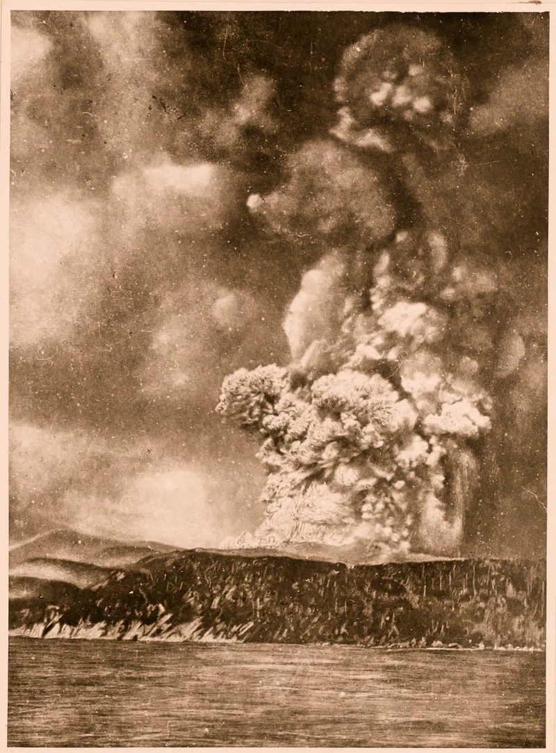
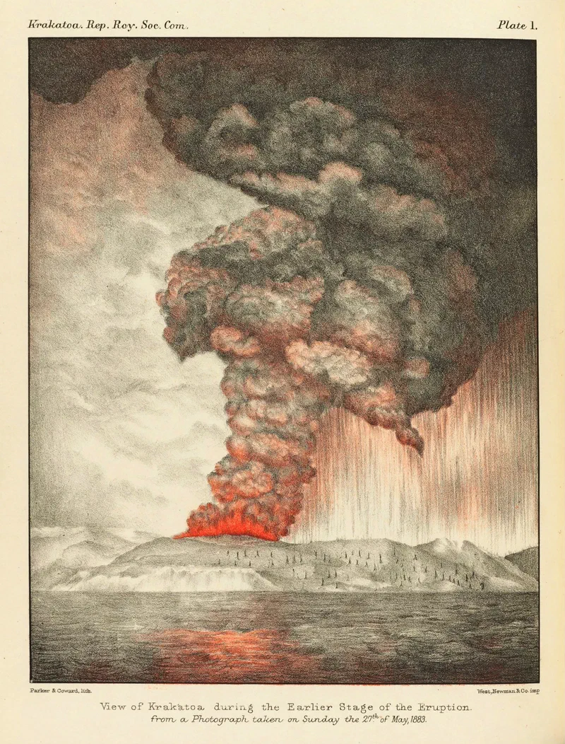
The following day, “Captain Olivari, of the Italian barque Carmelina” came into port at Singapore bearing news that as they were passing the Straits of Sunda earlier on 15th July – the narrow passage between the islands of Sumatra and Java – they had witnessed the “active eruption” of a volcano there from a distance of “5 or 6 miles”, which came “very nearly setting fire to the sails” and covered his vessel with “a quantity of lava”. Krakatoa had begun its relentless eruptive phase on 19 June 1883, a prelude to the cataclysm that has now come to pass.

Wednesday, 29 August

The Straits Settlements Government then received a stark telegram from the Netherlands Indies Government:

“Strong volcanic eruptions in Sunda Straits, Charts not be trusted at all, Lights destroyed”.

Allan Macclean Skinner, the Colonial Treasurer and founding member of the Straits branch of the Royal Asiatic Society, wrote to the Straits Times, insisting it was entirely possible the sounds were indeed from Krakatoa.

Thursday, 30 August

On Thursday morning at 7.00 a.m., another update arrived from Batavia:

“The whole district known as the Residency of Bantam is an ashy desert. Cattle foodless. Famine imminent. Population starving and in despair.”

Saturday, 1 September

By then, the Malayan public was beginning to grasp the scale of the disaster. “I looked for the arrival of the Straits Times yesterday (Friday) with much curiosity, to see if therein I could find any explanation of the sounds heard here last Sunday and Monday”, the correspondent at Selangor recounted.

The sounds along the west coast of the Malay Peninsula, from Singapore to Penang, were indeed from the eruption of Krakatoa, as Skinner had postulated. The eruption was an event of global proportions. The explosion was heard as far as Perth, Australia, and nearly 5,000 km away across the Indian Ocean at Mauritius. So powerful was the blast that “the acoustic pressure wave circled the globe more than three times”.

The following day, the Governor of the Straits Settlements received a grim telegram from the Governor General of the Netherlands Indies, hinting at the disaster’s human cost:

“Thanks for your kind offer; if necessary I will not fail to apply to you … extent of calamity yet unknown; in one single district ten thousand people were drowned. A whole province became a desert.”

The official figures by the Dutch later put the death toll at 36,417.

Crimson Skies

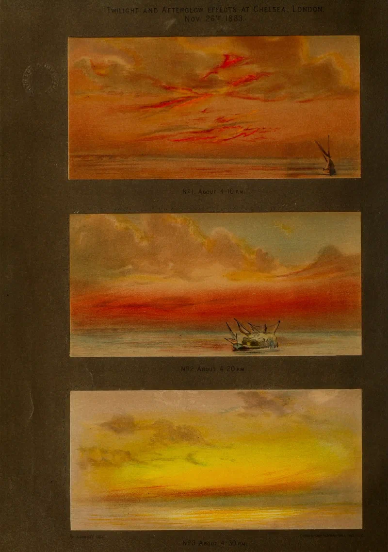
The Irish astronomer, Sir Robert Stawell Ball, who wrote much about Krakatoa, explained in his 1892 book, “The dust of Krakatoa had put a girdle round earth in thirteen days!” This “vast volume of dust in the air” caused a “wonderful series of optical phenomena” observed throughout the world after the eruption – spectacular sunsets. Ball, impressed by the speed with which the volcanic dust had reached every part of the planet, concluded the chapter with the remark, “How small the world is after all!”.

These Krakatoa sunsets, as they came to be known, were also observed in Malaya. One Penang resident who witnessed the phenomenon still recalled it vividly 19 years later, writing in the Pinang Gazette:

“Everybody must remember the remarkably vivid sunsets which accompanied … the Krakatoa Explosion in … 1883 … characterised not only by the brilliance but also by that indescribable weird eeriness which was the distinguishing feature of the Krakatoa sunsets”.

For some of us today, such descriptions may not be entirely unfamiliar. The eruption of Mount Pinatubo in the Philippines in 1991 also produced spectacular sunsets across Southeast Asia – can you remember them?

The Roar of Krakatoa Across the Straits of Malacca (1883) — image 1
The Roar of Krakatoa Across the Straits of Malacca (1883) — image 2
The Roar of Krakatoa Across the Straits of Malacca (1883) — image 3
The Roar of Krakatoa Across the Straits of Malacca (1883) — image 4

Sources :

  1. Straits Times (1883), “The Volcanic Outburst in Sunda Straits”, 6 October 1883, p. 3
  2. Straits Times Weekly Issue (1883), “How Krakatoa was Heard in Selangor”, 13 September 1883, p. 6
  3. Straits Times (1883), 27–31 August 1883
  4. Straits Times (1883), 1 September 1883
  5. Rogier Diederik Marius Verbeek (1886), Krakatau, pp. 533–538
  6. Straits Intelligence M09 1883, 1 September 1883, p. 2
  7. George James Symons (1888) (ed.), The Eruption of Krakatoa and Subsequent Phenomena, Report of the Krakatoa Committee of the Royal Society
  8. Robert Stawell Ball (1892), “In Starry Realms”, pg. 319–342
  9. De uitbarsting van de Krakatau, http://hdl.handle.net/1887.1/item:788817 , KITLV 5888, Leiden University Libraries Digital Collections (Photo)

https://www.eugenequah.com/blog/the-roar-of-krakatoa-across-the-straits-of-malacca-1883/

Copyright © 2026 Eugene Quah Ter-Neng. All rights reserved.

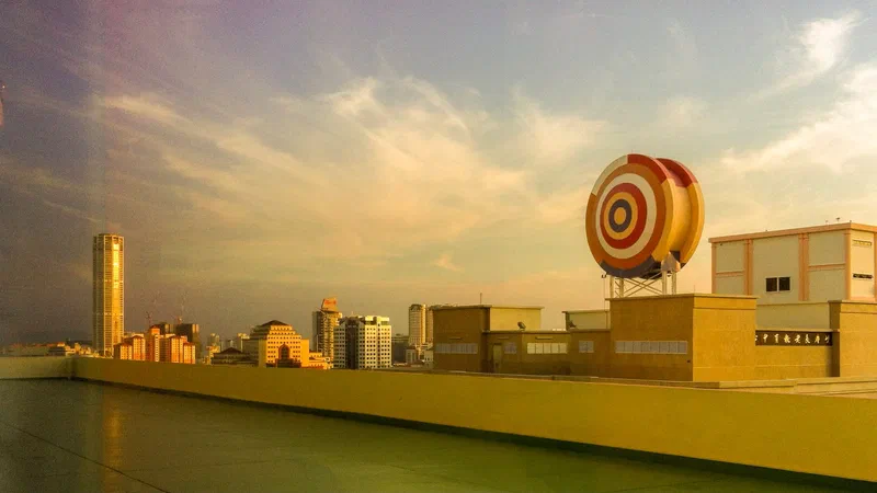
The George Town skyline from Gleneagles Hospital (2014)

The George Town skyline at sunset on 11 February 2014, photographed from a room in Gleneagles Hospital. If I recall correctly, I was recovering from dengue at the time, and the photo was taken with an iPhone 4.

Some points of interest:

On the far left stands KOMTAR (Kompleks Tun Abdul Razak), the tallest building in Penang since 1985. In this shot, it appears without the three additional floors that were added in 2015.

At the centre of the frame is Menara JKP, then known as Menara UMNO. Less than a year earlier, on 13 June 2013, at around 6.45 p.m., the building made headlines when a storm blew off its 20-metre lightning arrestor, tragically killing a passing motorcyclist at Macalister Road below.

To the far right is the rooftop of the extension wing of the Buddhist Triple Wisdom Hall (三慧讲堂) - No. 5 Pangkor Road - which took over the former site of the U.S. Consulate in 1964.

The George Town skyline from Gleneagles Hospital (2014) — image 1

https://www.eugenequah.com/blog/the-george-town-skyline-from-gleneagles-hospital-2014/

Copyright © 2026 Eugene Quah Ter-Neng. All rights reserved.

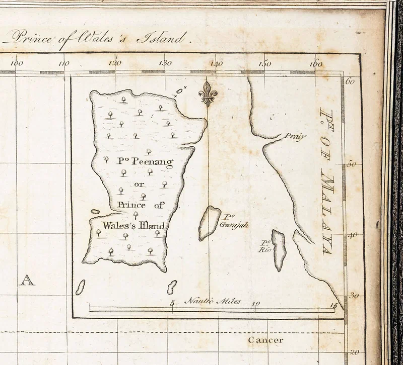
An Early Plan of Pulo Peenang or Prince of Wales's Island (1788)

This early map of Penang was published on 25 March 1788 by the English publisher John Stockdale, whose shop stood “opposite Burlington-House” at Piccadilly, London. Issued just less than two years after Francis Light took possession of the island, it depicts the surrounding islands of Pulau Tikus, Pulau Kendi, Pulau Rimau, Pulau Betong, Pulau Jerejak and Pulau Kra (now Pulau Aman) in roughly their correct positions relative to the main island.

Only three islands are named on the map: Pulo Peenang – a phonetic rendering of the Malay pronunciation – Pulo Gerajah (Pulau Jerejak), and Pulo Rio, likely a misheard version of Pulau Kra. On the Kedah mainland opposite Penang Island appears the label Point of Malaya – probably intended to mean the Peninsula. Two rivers are also marked: Sungai Jawi (unlabelled) and Sungai Prai, here spelt “Praiy”.

In these early years, Penang was also known as Prince of Wales’s Island – note the double-s possessive in “Wales’s”, a style of the period also used by Francis Light in his own documents.

An Early Plan of Pulo Peenang or Prince of Wales’s Island (1788) — image 1

Source:
Extracted from an inset of “A general chart of the Atlantic and Indian oceans with the situation & plan of Pulo Peenang or Prince of Wales’s Island”, published 1788.

https://www.eugenequah.com/blog/an-early-plan-of-pulo-peenang-or-prince-of-waless-island-1788/

Copyright © 2026 Eugene Quah Ter-Neng. All rights reserved.

AI, large language models and local history

My latest article in Penang Monthly explores how AI – more specifically, Large Language Models (LLMs) such as ChatGPT – can be powerful tools for historical research and storytelling. Used thoughtfully, AI-based tools can help uncover and connect details from diverse sources and tease out lost details from old photos; used carelessly, however, they may unintentionally create versions of the past that never existed.

This topic feels especially relevant today, as I noticed a widely circulated but incorrect date for a well-known temple resurface in one of Penang’s interest groups, the exact example used in the article. The poster, of course, shared it in good faith, as the incorrect information has been reposted by many others for years. This is precisely why, as a community, we can work together to stay alert, encouraging the careful use of AI and practising community-based fact-checking, so that our rich heritage remains rooted in authentic history.*

* hidden in the article is a three-layer pun for those with powerful Hokkien to enjoy

Full article:

https://www.penangmonthly.com/keeping-penangs-story-real-in-the-age-of-artificial-intelligence/

https://www.eugenequah.com/blog/ai-large-language-models-and-local-history/

Copyright © 2026 Eugene Quah Ter-Neng. All rights reserved.